

We got back on the main road and headed further up the mountain.
It was a continual climb, getting steeper as we went and the already gutless Jimmy was sown to 3rd and even second gears as we approached the summit because of the altitude, which was over 3000 metres at the top.
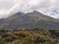
From there there was an incredible view into the volcanic crater which must be around 10 km in diameter, with a large lake in the bottom, and a couple of surrounding peaks that are considerably higher.
One of theses had erupted dangerously in 1963 apparently, and had destroyed a sizable village of the local Bali Aga people who live there. It was still obvious where the eruption had left scarring from the top of the small mountain in the crater even after all these years.
It was a very steep descent onto the crater with fantastic views emerging at every corner. At the bottom we went left which led past a big spa swimming pool complez and through the ghostly remains of the village destroyed in the eruption.
Many of the main structures remained so I was curious why they hadn't been re-occupied, but I guess at the time they would have been surrounded by solidified lava and onwhere to grow food etc. Plus I guess there would be fear and superstition of the eruption reoccuring.


Further on we were diverted from the main road that leads eventually to the other side of the mountain, due to it being closed during celebration time.
This led is through the current location of the Bali Aga village. Clearly there was a lot of poverty, the village very reminiscent of some of the poor areas we'd see in India. Whether this is just a legacy of the eruption and reduced tourism after the Bali bombing I don't know.
According to our host these people keep very much to themselves, and their origins are different to most other Balinese.
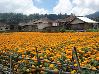
 Eventually we reached the end of the road and came back through the fields of onion and cabbage etc growing there.
We found a small warung to have some lunch of nasi goreng and noodles.
The clime out of crater was 1st gear a lot of the time because it was so steep, but once we reached the top we turned to descend the other side of the mountain, a very lush and prosperous looking area compared to the Bali Aga village.
The long descent through heavy rain was punctuated by what sounded like a pinctire, but luckily was a short bolt stuck in the tyre, not deep enough to pierce it.
Bolt removed, we carried on towards Klungkun which is a large town with one of the larger Muslim population in Bali. It was a pleasant, clean looking town.

From there we soon met the coast and followed this around toward Padangbai, which in the point ferries leave for Lombok. We went through the smallish village and over a headland to a small sheltered beach recommended for swimming in the guidebooks.
It turned out to be low-tide though, so wasn't ideal, with a very strong undertow, and quite big waves that battered your feet with largish chunks of coral and stones.
We left as it was getting dark, so the drive home meant a few stops to get directions from locals, largely obliging, and led us to the shorter flatter route back to Ubud, as Eunmi and the kids slept.


No comments:
Post a Comment